Sibillini Mountains: The Italian Alps Nobody Visits (And Why That’s Starting to Change)
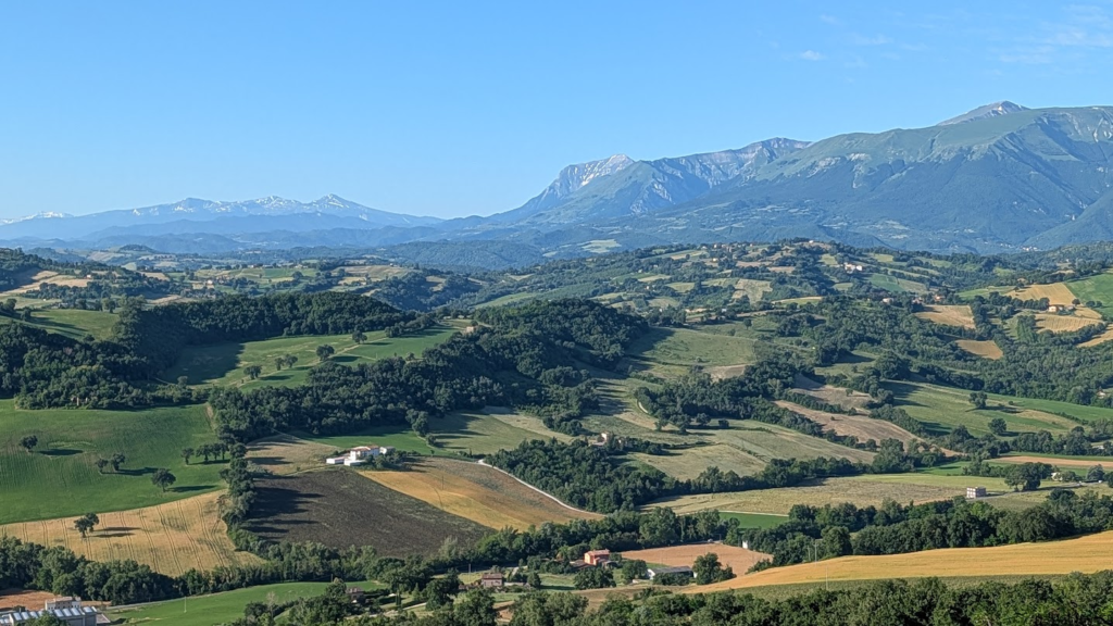
Stand on almost any ridge in the Maceratese hinterland of Le Marche on a clear morning and the western horizon does something unexpected. It stops being hills. A wall of blue-grey rock rises where the gentle Apennine folds should continue, jagged in a way that the rest of central Italy’s landscape does not prepare you for. Twenty peaks above 2,000 meters (6,560 feet). A high plain that turns crimson and gold with wildflowers every June. A lake that runs blood-red for a few weeks each summer, home to a crustacean that exists nowhere else on Earth. This is the Sibillini range, and I need to correct something before we go any further, because getting it wrong is the single most common mistake American visitors make about Italian mountains.
The Sibillini are not the Alps. They are the Apennines — the spine of peninsular Italy, geologically and culturally distinct from the glaciated giants along the French and Swiss border that most Americans picture when they hear “Italian mountains.” I use “Alps” in this title deliberately, because that is the mental image the phrase “Italian mountains” produces for most of my American readers, and because the correction itself is the first thing worth knowing about this range: the wildest, least-visited high country in central Italy is not where you’d look for it, and almost nobody outside Italy has heard its name. I live thirty minutes from these mountains. I have walked them in January snow and July heat, and what follows is the range as I know it — not as a tourist board would describe it.
A National Park Between Two Regions
The Parco Nazionale dei Monti Sibillini was established in 1993 and covers roughly 70,000 hectares (173,000 acres) straddling the border between Le Marche and Umbria, across eighteen comuni in four provinces: Ascoli Piceno, Fermo and Macerata on the Marche side, Perugia on the Umbrian side. Sixteen of the eighteen park municipalities are Marchigiano — Amandola, Arquata del Tronto, Bolognola, Castelsantangelo sul Nera, Cessapalombo, Fiastra, Montefortino, Montegallo, Montemonaco, San Ginesio, Ussita, Visso and others — with only Norcia and Preci on the Umbrian side. This matters for orientation: while the range’s most photographed feature, the high plain of Castelluccio, sits administratively in Umbria, the mountains themselves belong overwhelmingly to Le Marche, both in territory and in the character of the villages that ring them.
The park protects a fourth-highest massif of the continental Apennines, after the Gran Sasso, the Maiella and the Velino-Sirente ranges — a fact that surprises visitors who assume the Apennines are uniformly gentle. They are not. The Sibillini’s limestone core was shaped by Quaternary glaciation into U-shaped valleys and true glacial cirques, the same processes that carved Alpine valleys further north, compressed into a range barely 40 kilometers (25 miles) long from end to end.
The Peaks: Vettore and the High Ridge
Monte Vettore is the range’s highest point at 2,476 meters (8,124 feet) — the name derives from the Latin victor, because it rises above every other peak in the Sibillini chain. Vettore’s summit sits at the meeting point of three municipal territories — Norcia in Umbria, Arquata del Tronto and Montegallo in Le Marche — and offers, on a clear day, a panorama that reaches the Gran Sasso and the Laga mountains to the southeast, the Sibillini’s own secondary peaks, and on the clearest days the Tyrrhenian-facing ranges of Tuscany and Lazio.
The high ridge running from Vettore toward the Cima del Redentore (2,448 meters / 8,032 feet) is the range’s signature traverse — a rare stretch of true alpine ridge-walking in central Italy, exposed and demanding, that experienced hikers treat as the Sibillini’s defining route. Monte Priora (2,332 meters / 7,651 feet) and Monte Sibilla (2,173 meters / 7,129 feet) complete the range’s principal summits, each with its own access valley and its own character: Priora rising above the Infernaccio gorge, Sibilla — the mountain that gives the entire range its name — visible from Montemonaco as a dark pyramid that has haunted the European imagination since the Middle Ages, for reasons I’ll return to.
Lago di Pilato: A Glacial Lake That Turns Blood-Red
Beneath Vettore’s summit, inside a glacial cirque at 1,940 meters (6,365 feet), sits the only natural lake in Le Marche and one of the very few true alpine-type glacial lakes anywhere in the Apennine chain. Its size and shape change through the season — depending on snowmelt and rainfall, it can appear as a single body of water or split into two connected basins, which has earned it the local nickname il lago con gli occhiali, “the lake with glasses.”
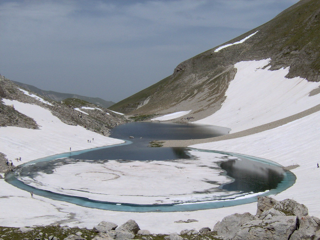
Lago di Pilato hosts a species found nowhere else on the planet: the Chirocefalo del Marchesoni, a small endemic crustacean whose population, in certain conditions during summer, colors the entire lake a striking red. This is not algae or sediment; it is a living population of an organism that exists, in its wild state, in this single body of water and nowhere else on Earth. The lake’s water level drops through the summer months, and the crustacean population’s visibility depends on conditions that vary year to year — this is not a guaranteed spectacle you can schedule, and any visitor should treat it as a possibility rather than a promise.
The name attaches to a medieval legend with a genuinely dark undertone: the lake was believed to be the resting place of Pontius Pilate’s body, dragged there by oxen after his death and condemnation, its waters considered — in the medieval imagination that shaped so much of this range’s folklore — an entrance to the underworld. The trail to Lago di Pilato from the hamlet of Foce di Montemonaco was closed after the 2016 earthquake sequence and reopened to foot traffic in 2018, following safety assessments; as with any mountain trail in this range, conditions should always be checked with the relevant comune before setting out, since weather and rockfall risk can produce temporary closures independent of the earthquake’s aftermath.
Castelluccio and La Fiorita: Beauty Growing Out of Ruin
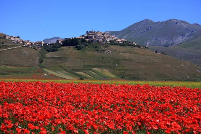
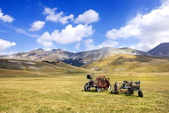
The Piano Grande of Castelluccio di Norcia, at 1,452 meters (4,764 feet), is the range’s most photographed landscape and the site of la fiorita — the flowering of the high plain’s cultivated lentil fields and wild meadow together, a sequence of colors moving from yellow mustard through red poppy to blue cornflower across roughly six weeks between late May and mid-July. In 2026, the chromatic peak is expected between June 15 and July 15, though — as anyone who has tried to schedule around it will tell you — there is no fixed date; the sequence depends entirely on that year’s temperatures and rainfall, and it should be treated as a window to watch rather than a date to book.
I want to be honest here about something most travel coverage of Castelluccio glosses over. The village was almost entirely destroyed by the earthquake of October 30, 2016 — approximately 99 percent of its homes and non-commercial buildings were destroyed, damaged or subsequently demolished. Ten years later, reconstruction remains substantially on paper. Three families live in the village year-round, along with two young residents who returned to be part of the rebuilding effort; commercial activity operates out of temporary structures. A 68-million-euro project to rebuild the historic center on a seismically isolated platform — using 300 base isolators beneath the entire settlement, a technique without precedent at this scale — has been designed and is moving through Italy’s public reconstruction bureaucracy, but as of 2026 it remains a project rather than a built reality.
This is not a reason to avoid Castelluccio. The plain itself was not directly damaged by the earthquake and remains fully accessible; the fiorita has continued, uninterrupted, every single year since 2016, indifferent to the human timeline of reconstruction happening around it. What it means is that a visit to Castelluccio in 2026 is a visit to two truths at once: one of the most extraordinary flowering landscapes in Europe, and a village still, honestly, waiting for itself to come back. I don’t think either truth should be hidden from a visitor, and I don’t think either one cancels the other out.
Gorges, Canyons, and a Turquoise Lake
Beyond the high peaks, the Sibillini’s erosional landscape produces some of central Italy’s most striking accessible scenery. The Gole dell’Infernaccio, on the Marche side near Montefortino, is a genuine canyon carved by the Tenna river through limestone walls, leading to the Eremo di San Leonardo — a hermitage damaged by the 2016 earthquake, now stabilized, its access trail restored with a dedicated investment of roughly 150,000 euros in bridges and pathway repair. The trail is rated easy-to-moderate, suitable for families with children accustomed to walking, and typically open from May through November, subject to the comune’s seasonal ordinances on weather and rockfall risk.
The Lame Rosse, near Fiastra, are a badland formation of red-and-ochre eroded pinnacles that look more like the American Southwest than anything the word “Apennine” suggests — a genuinely surprising landscape produced by differential erosion of soft sedimentary rock, reachable by an accessible trail from the shore of Lago di Fiastra, an artificial reservoir built in 1949 whose turquoise water has become one of the range’s most photographed lower-altitude features.
For visitors with more time, the Grande Anello dei Sibillini is a multi-day circuit of roughly 120 kilometers (75 miles) that traces the range’s full perimeter, typically walked in about a week with overnight stops in the gateway villages — the single best way to understand the Sibillini as a connected landscape rather than a list of individual sights.
The Sibilla: Why These Mountains Carry a Woman’s Name
The range takes its name from a specific and very old European legend, one that deserves more attention from English-language travel writing than it typically receives. According to medieval tradition, a prophetess — the Sibilla Appenninica — lived in a cave on the mountain that now bears her name, ruling over an enchanted realm and dispensing prophecy to those with the courage to seek her out. Through the Middle Ages, the Sibillini were known across Europe as a realm of demons, necromancers and fairies — a reputation serious enough that the range attracted actual pilgrimage from practitioners of medieval magic, who traveled here specifically because they believed the mountains offered access to the supernatural.
This legend did not stay local. It traveled into major works of medieval and Renaissance European literature: the Guerrin Meschino, the widely read chivalric romance by Andrea da Barberino, sends its knight-errant protagonist to the Sibilla’s cave in search of answers; the fifteenth-century French author Antoine de la Sale, in Le Paradis de la Reine Sibylle, describes his own journey to the mountain and the court he claims to have found there; the myth has even been connected, by some scholars, to the German Tannhäuser legend and its enchanted Venusberg. A local place-name — the Fonte del Guerin Meschino, a spring near the Infernaccio gorge — still marks the literary geography directly onto the landscape.
None of the other Apennine ranges carries this kind of literary weight. The Gran Sasso and the Maiella are geologically comparable and, in places, higher; neither has a documented medieval European literary tradition attached to a specific peak. The Sibillini do, and it is one of the more genuinely distinctive things about this range that almost no English-language coverage mentions.
The medieval myth was not this range’s last brush with literature, either. Two centuries later, the poet Giacomo Leopardi — watching from his family’s palazzo window in Recanati, less than an hour east of the park’s approaches — gave the Sibillini a second name in his 1829 poem Le Ricordanze*: i Monti Azzurri, the Blue Mountains, for the pale blue-grey cast they take on when seen from a distance on a clear day — the same optical trick that opens this very article. The name outlived the poem. It survives today in the Comunità Montana dei Monti Azzurri, the local administrative body governing part of this territory, and in the way people across the Maceratese still call the range by it without a second thought. I’ll have much more to say about Recanati, Leopardi and that view in a piece of its own soon.*

What’s Coming Back: The Real Story of Change in These Mountains
If there is a legitimate case for “why this is about to change,” it is not reconstruction — Castelluccio’s village fabric, as I’ve been honest about above, remains largely unbuilt ten years on. The real, verifiable change in these mountains is ecological, and it is happening faster than almost anyone predicted.
The Apennine chamois (Rupicapra pyrenaica ornata) — a subspecies found only in central Italy, reduced to as few as forty individuals nationwide during the Second World War — was reintroduced to the Sibillini starting in 2007-2008, translocated from the surviving population in Abruzzo’s national parks. As of the most recent counts, the park’s biologist described the population’s trajectory as exponential growth: an autumn 2024 count estimated roughly 500 individuals, with a partial summer 2025 census already recording 264 animals in surveyed high-altitude zones alone, and the population now expanding beyond its original release area at Bolognola into new territory around Monte Priora. This is one of the more successful large-mammal reintroduction programs in Europe, recognized with awards from both WWF Italy and the European Commission.
Golden eagles have shown a comparably dramatic recovery: just two confirmed nesting pairs were recorded when the park was established in 1993; by 2025, the count had reached eight nesting pairs, one of the highest densities in the entire Apennine chain, aided by the chamois reintroduction’s knock-on effect on the broader prey base. The Apennine wolf, never extirpated from this range the way the chamois was, remains present throughout, along with wildcat and porcupine populations that have expanded significantly in recent decades.
What this adds up to is not a marketing narrative about a mountain range “about to be discovered.” It is a genuine, documented ecological recovery happening in real time, paired with what the park’s own biologist — in a summer 2025 interview — called, without prompting, “a great rediscovery of the mountain, especially our Sibillini.” That rediscovery is visible in the growing number of hikers and wildlife photographers making the trip specifically to see chamois in their high-altitude habitat, in the increasing profile of the fiorita in international photography circles, and in the slow but real growth of outdoor and slow-tourism interest in a range that, for most of the past three decades, existed almost entirely outside Italy’s international tourism conversation.
The Fault Beneath the Beauty
An honest account of these mountains has to include what produced their most difficult recent chapter. The Sibillini sit above one of the most seismically active fault systems in the Apennines — specifically the Vettore-Bove fault system, a normal fault whose reactivation in 2016 produced the central Italy earthquake sequence that devastated Amatrice, Norcia, Accumoli and dozens of smaller communities including Castelluccio, and that damaged the trail infrastructure throughout the park.
As an engineer, I read this landscape’s beauty and its danger as the same phenomenon viewed at different timescales. The glacial cirques of the Vettore and Monte Bove, the U-shaped valleys, the karst depressions that produced the Piani di Castelluccio — all of this is the visible record of the same tectonic and glacial forces that, on a much shorter timescale, produced the earthquake sequence of 2016-2017. The Cordone del Vettore — locally known as the Sentiero delle Fate, the Fairy’s Path — is a fault scarp, a visible line of ground displacement that reactivated during the 2016 quake and remains one of the most legible pieces of active tectonic geology visible from any hiking trail in Italy. Walking past it is walking past the mechanism, not just the metaphor, of how this landscape continues to make itself.
This is not a reason for alarm. It is a reason for respect, and for checking trail conditions before setting out — a habit any serious mountain hiker practices anywhere, and one that this particular range, more than most in Italy, rewards taking seriously.
The Villages at the Edge
The Sibillini are accessed almost entirely through a ring of small Marchigiano and Umbrian towns, each serving as gateway to a different sector of the park. Montemonaco, on the eastern flank, is the departure point for Lago di Pilato and the Grotta della Sibilla itself. Montefortino gives access to the Gole dell’Infernaccio and the Santuario della Madonna dell’Ambro, the oldest sanctuary in Le Marche, built roughly a thousand years ago — according to local tradition, specifically to counter the Sibilla’s pre-Christian mythology with a Christian devotional alternative. Amandola, a larger town on the range’s eastern approach, anchors the southern access routes. Bolognola and Ussita serve the northern sector and, in winter, the modest ski infrastructure at Frontignano — small by Alpine standards but a genuine local winter destination. Fiastra gives access to the Lame Rosse and its artificial lake. Visso, seat of the park authority itself, anchors the northern Val Nerina approach.
On the Umbrian side, Norcia — famous for its cured meats and, since 2016, for its own extensive earthquake reconstruction — is the principal gateway to Castelluccio and the Piano Grande.
San Ginesio, the hilltop town I’ve written about elsewhere on this site, sits within the park’s administrative territory and calls itself, with real justification, il balcone dei Sibillini — the Sibillini’s balcony — for the view these mountains offer from its walls.
Planning Your Visit
Getting there. The Sibillini require a car; there is no direct rail access to the mountains themselves. The nearest rail stations are Macerata, Ascoli Piceno, Foligno and Spoleto, all requiring a further 30-60 minute drive into the gateway towns. From the A14 motorway (Bologna-Bari), exit at Civitanova Marche, Pedaso or San Benedetto del Tronto depending on which sector you’re approaching. From the A1, exit at Orte or Val di Chiana and approach via the SS4 Salaria or the Valnerina road. Ancona’s airport is roughly 90 minutes from the range’s northern gateway towns.
When to go. Late May through mid-July for the fiorita and the wildflower sequence more broadly; be aware the exact peak shifts year to year and cannot be scheduled precisely more than two to three weeks in advance. Summer (July-August) for full trail access and the best chance of favorable Lago di Pilato conditions. Autumn for beech forest color and quieter trails. Winter for Frontignano’s modest ski slopes and a genuinely different, silent version of these mountains that very few foreign visitors ever see.
Trekking. The Grande Anello dei Sibillini (120 km / 75 miles) for a full multi-day circuit; the ascent of Monte Vettore for a serious but non-technical day hike; the Gole dell’Infernaccio and the Lame Rosse for accessible, family-suitable half-day excursions. Always verify current trail conditions with the relevant comune or the park authority before setting out — seasonal closures for weather, rockfall or residual earthquake-related risk are normal and should be respected, not treated as bureaucratic caution to route around.
Where to stay. The gateway villages — Montemonaco, Montefortino, Amandola, Visso, Fiastra — offer agriturismi and small hotels rather than large-scale accommodation; booking during the fiorita weeks and in August requires advance planning. For travelers who want genuine comfort at altitude without sacrificing access to the range, curated glamping experiences in the wider Marche interior — the kind I track through the dolceglamping waiting list — offer a way to be close to these mountains without roughing it entirely.
What to eat. The Lenticchia di Castelluccio IGP, grown above 1,400 meters without chemical treatment and needing no pre-soaking before cooking; lamb from the high pastures; pecorino aged in mountain farms; ciauscolo, the spreadable Marchigiano salume. This is the food of the Mediterranean diet’s mountain register — simpler, more austere, and more dependent on altitude than the coastal Marchigiano kitchen.
FAQ — The Sibillini Mountains for the American Visitor
Are the Sibillini Mountains part of the Alps? No. The Sibillini are part of the Apennines, the mountain chain that forms the spine of the Italian peninsula, geologically and historically distinct from the Alps along Italy’s northern border. They are, however, the fourth-highest massif of the continental Apennines and contain genuine glacially-carved high-altitude terrain — U-shaped valleys, cirques, and a true glacial lake — that produces scenery unusually dramatic for a range most Americans have never heard of.
How high is Monte Vettore, the tallest peak in the Sibillini? Monte Vettore reaches 2,476 meters (8,124 feet), making it the highest point in the Sibillini range and one of the more significant peaks in the entire Apennine chain. The name derives from the Latin victor, referring to its dominance over the surrounding peaks.
What is Lago di Pilato and why does it turn red? Lago di Pilato is a glacial lake at 1,940 meters (6,365 feet) beneath Monte Vettore’s summit — the only natural lake in Le Marche and one of the few true alpine-type glacial lakes in the Apennines. It hosts the Chirocefalo del Marchesoni, an endemic crustacean found nowhere else on Earth, whose population can color the water red under certain seasonal conditions. The phenomenon is not guaranteed on any given visit and depends on water levels and population dynamics that vary year to year.
Is Castelluccio di Norcia rebuilt after the 2016 earthquake? No, not substantially. Ten years after the earthquake, roughly 99 percent of the village’s homes and non-commercial buildings remain destroyed, damaged, or demolished, with only a handful of resident families living there year-round. A major reconstruction project — rebuilding the historic center on a seismically isolated platform — has been designed but remains largely in the planning and early-implementation phase as of 2026. The surrounding Piano Grande plateau was not directly damaged and remains fully accessible, and the annual fiorita has continued uninterrupted every year since the earthquake.
When is the best time to see the Castelluccio fiorita in 2026? The chromatic peak is generally expected between mid-June and mid-July 2026, though the exact timing shifts year to year depending on temperature and rainfall and cannot be predicted precisely more than two to three weeks in advance. The full flowering sequence runs roughly six weeks, from late May through mid-July, moving through distinct color phases as different species bloom in succession.
Why are the mountains named after the Sibilla? Medieval legend held that a prophetess, the Sibilla Appenninica, lived in a cave on the mountain that bears her name, presiding over an enchanted realm. The legend was significant enough in medieval Europe to appear in major literary works, including the chivalric romance Guerrin Meschino and Antoine de la Sale’s fifteenth-century account of his own journey to the Sibilla’s court, and some scholars connect it to the German Tannhäuser legend. Throughout the Middle Ages, the range was known across Europe as a realm associated with demons, necromancers and fairies.
Is wildlife actually recovering in the Sibillini, or is that marketing? It’s genuinely documented. The Apennine chamois, reintroduced starting in 2007-2008 from Abruzzo’s surviving population, has grown from a handful of founding individuals to roughly 500 by 2024, with the park’s own biologist describing the trajectory as exponential growth. Golden eagle nesting pairs have grown from two at the park’s founding in 1993 to eight in 2025, one of the highest densities in the Apennines. Both recoveries are documented through the park’s own scientific monitoring programs, not tourism promotion.
The Final Word
The Sibillini are not a secret in the sense that word usually implies in travel writing — nobody is hiding them, and the people who live in their gateway villages would very much like more visitors to come, respectfully, and see what they’ve spent decades protecting. They are simply outside the conversation most Americans have about Italian mountains, which runs almost exclusively toward the Dolomites and the western Alps. That conversation has never had room for a range that sits two hours from Rome, carries a medieval European myth in its name, still bears the visible scar of a 2016 earthquake, and is currently watching a species that nearly went extinct in living memory reclaim its slopes in real time.
I don’t think the Sibillini need a marketing campaign. I think they need visitors who arrive knowing what they’re walking into — the geology, the myth, the fault line, the chamois, the still-unrebuilt village — and who treat all of it with the same attention. That is, in the end, the only kind of “discovery” a place like this actually deserves.
Planning a Le Marche itinerary that includes the Sibillini? I offer 30-minute travel consultations to help sequence mountain time with the region’s villages, food and festivals — book through TidyCal.